Wednesday, February 29, 2012

Malaysia Deforestation Is Three Times Faster Than Rest Of Asia Combined

I pulled out a story today being posted by my friend on facebook. It was a post by Huff Post Green.
28 Feb 2012- New satellite imagery shows Malaysia is destroying forests more than three times faster than all of Asia combined, and its carbon-rich peat soils of the Sarawak coast are being stripped even faster, according to a study released Tuesday.

The report commissioned by the Netherlands-based Wetlands International says Malaysia is uprooting an average 2 percent of the rain forest a year on Sarawak, its largest state on the island of Borneo, or nearly 10 percent over the last five years. Most of it is being converted to palm oil plantations, it said.

The deforestation rate for all of Asia during the same period was 2.8 percent, it said. In the last five years, 353,000 hectares (872,263 acres) of Malaysia's peatlands were deforested, or one-third of the swamps which have stored carbon from decomposed plants for millions of years.

The study was carried out by SarVision, a satellite monitoring and mapping company that originated with scientists at Wageningen University in the Netherlands.

"Total deforestation in Sarawak is 3.5 times as much as that for entire Asia, while deforestation of peat swamp forest is 11.7 times as much," the report said.
Only yesterday I was writing a post about how we wouldn't know the total land cover in Sarawak, but today there is a company Netherlands was able to calculate the total and type of land area being converted to agriculture over the past 5 years. How amazing!

My biggest question would be how did they obtain the data of Malaysia (specifically Sarawak) land cover 5 years ago. I bet that would be the similar question posted by Malaysian government too.

Tuesday, February 28, 2012

Young Hornbill

Horn bill! Who wouldn't be excited to see one, especially if it is young, wild and is somewhere reachable to you?
This is a young unsub horn bill. Nobody was a bird specialist there, so no one knows the species and gender of this horn bill. But what they do know, it has become friendlier and talkative!
Its favorite place is the kitchen area. As the ladies in the kitchen fed it when it was young, it has became dependent to them. No one understood how this baby got strayed away from it's parents as horn bill are pretty protective to their young ones. Here is another picture of it "talking". It makes the sound " Urngh Urngh Urngh" all the time. Non stop!
Clearer picture to whom it was talking to. Pity Mr. Meow couldn't have it's meal peacefully.
  And here it is turning to get a candid picture shot!
 Please let me know if anyone of you knows the gender and species of this horn bill, thanks!

~Happy Reading~

Monday, February 27, 2012

FERN: VPA Malaysia Update

It is a 2 months old post of update the current VPA status in Malaysia:

 
One of the big blockage of the VPA EU-Malaysia signing is directly related to the in-openness of Sarawak government to the current state status, especially related to native customary rights of land use and forest area. Adding to it, Sarawak government feels land area pertaining native customary right issues and selection of contractors are not suppose to be part of the VPA requirement because it is not a certification or legality element. Hence, when the public or international body relates the both issues, together with the history of the poorly managed Penan issues, automatically the timbers from the state itself became controversial. And they directly link to the part where in Sarawak recorded significant volume of timbers are being exported every year. 

If at the starting point we are still discussing about human rights, it will be a long way before we canlook at something that can better improve the livelihood and forest for the future.

~What lies in our power to do, lies in our power not to do, Aristotle~

Sunday, February 26, 2012

Contradicted Headline: Royal Belum Still Untouched

I find this a very contradicting headline as I was expected to read an article of a 130 million years old forest that was not logged since "ever" being protected from log harvesting in Peninsular Malaysia! 


Just to find out the headline was highlighting that there were no illegal logging activities detected in The Royal Belum Forest, Hulu Perak. No illegal logging being detected does not mean there were no logging was permitted nor human settlement. Aerial survey can detect only phenomenal changes of the area, but not if the logging was done in scatter or small scale. 

I wondered if this article was posted for people questioning why harvesting is permitted in the Temenggor FR that is part of the Belum Forest Reserve. Same question I would have posted to the government whom allows harvesting operation at the buffer of Maliau Basin, the Virgin Jungle Reserve. Or if it is an indication the is a plan to have a log-harvest tperation in this forest area. Hope not!!!

Although the article mentioned that more stringent standard has been imposed on the logging contractors in terms of size of trees felled and proper reforestation program, what worries me is what does it meant with proper reforestation program. Since harvesting in Peninsular Malaysia practices Selective Felling, means selected tree  with sizes allowable for felling and area being harvested should be left AFTER harvesting  for regeneration over a period of time. And, normally reforestation programs are being plan for area that has been degraded and are not able to regenerate naturally back.

From the article posted, I also interpreted that illegal logging is more prone to area that has been open for logging operation. This is probably due to because the roads has been open and it is more easily to access to the forest area.
 
More details about the Royal Belum State Park -Royal Forest

Quoted from the Royal Belum Nature Park website
The entire forest of Belum and Temenggor was considered a ‘black area’ and was placed under a State of Emergency from 1948 until 1989.  The communist party of Malaya was extremely active in that area and according to sources; the East-West Highway proposed by an army General believed cutting a road through the area would hamper the communists’ movements.  However, this road was constantly under threat of being bombed and sabotaged by renegades.  Peace has since reigned over the area after the signing of the Haadyai Accord in 1989
Source: WWF Website

Royal Belum forest reserve is situated northern most corner of Perak, sharing border with Thailand. Quoted from the Belum Outdoor website:
Located in Northern Perak district, Malaysia, the area is surrounded by Thailand border on the northern side, East-West highway on the Southern side and state of Kelantan on the Eastern side. The area shares border with Bang Lang National Park, Thailand and Hala Bala Wildlife Sanctuary, Thailand. The Royal Belum State Park was established in the year 2000. In July 2003, the Belum forest was known as “Royal Belum”. Officially gazetted as the Royal Belum State Park on May 3rd 2007. Royal Belum State park has land mass of 117,500 hectares which cover almost 50% of total Belum Temenggor Forest Reserve (300,000 hectares).

 Source: Belum Outdoor Website

Does anyone knows why is it call the Royal Belum? Translate "belum" to English means "not yet", Royal Belum is equivalent to "Royal Not Yet".


Tuesday, February 21, 2012

Picture of the Day: Unique Mineral Water Source

Was on the car journey from Sandakan to Keningau and we bypassed Bukit Taviu. We stopped at the roadside for a while as the car driver wanted to fill in his water bottle with the water, like this:

It was believed by the local people that this water have natural source ingredients that have mineral contents and better than normal mineral water, it also believed that it can help to cleanse the toxic out of the body.

And more than a year ago, I took the picture of the same spot where I did filled up my emptied water bottle with this water.


Now, would you drink the natural mineral water from that source? ;)

Monday, February 20, 2012

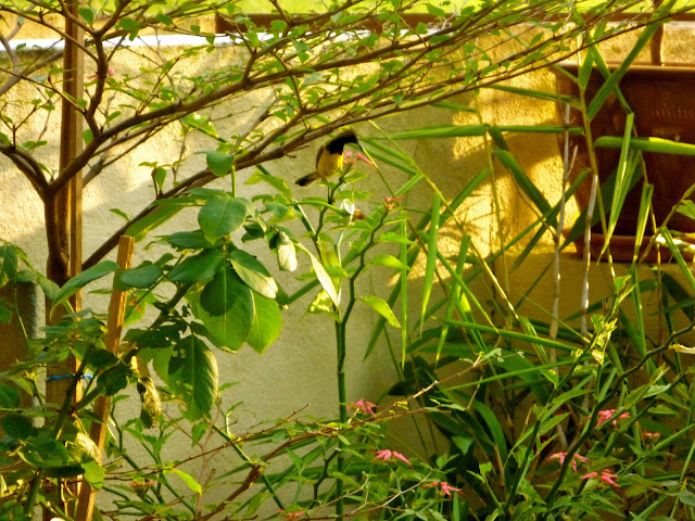
Olive-backed Sunbird in my Garden!

Chirping in my garden in the evening!


This bird is known as olive-backed sunbird or the specie name is Cinnyris jugularis. It was first sighted at my house last October 2011, and it was not easy to take a picture of it until last week! I did some research and found that this sunbird was originally from mangrove area, however has adapt well with the humans, hence it is  commonly sighted in overpopulated area. 

The picture above is the male sunbird. The female does not have a black ring around it's neck. Olive-backed sunbird can be found from Southeast Asia (Philippines, Vietnam, Malaysia) to Australia (New Guinea, Wallacea).  Differ from the picture shown in Wikipedia, this bird is thinner and longer, perhaps adapting to the South East Asia humid weather. And  it looks a lot cuter, than the one in the Wikipedia! :)

As it is a song/sunbird, it favors nectar feeding (over feeding on small insects). It looks like a passerine bird, the perching bird. Therefore, it will perch on flowers for nectar, like it comes to my garden to perch from the pink flower (which is the form of pink birds gathering). And I noticed it comes early in the morning, cloudy afternoon or favorably in the evening. There were once or twice I seen it coming in couple.

Although I am not staying in the city or any major town, but my place is still considered a quite heavy populated area. And to see another specie of bird (other than crows, swallow and common brown birds) in my housing area, or better in my garden, is an rare opportunity. I don't need to go often to KL Bird's Park to see birds in an open area. :)

FYI, it is no longer afraid of me. Only last 2 days, it lets me take photo of it face to face.

Hope you enjoy reading my entries as much as I enjoy writing it. :)

Updated on 1st of March 2012.

The flower plant this olive-backed sunbird is feeding on:

Thursday, February 16, 2012

Don't Flush Tiger Forest

I like this video. Tho Passeo toilet paper brand is not selling in Malaysia, but it is an interesting video to show how you can be a responsible purchaser.


Wednesday, February 15, 2012

Gaharu Trees felled Illegally at Penang Botanic Gardens

Gaharu tree was reported to be illegally felled at Penang Botanic Gardens last Sunday 12 Feb 12 on Valentine's Day. The Malaysian authorities had arrested a Vietnamese allegedly felling the trees in the rainforest near the Penang Botanic Gardens and other areas.  There are remaining 2 more suspects believed to be involved in the case has not been detect yet.They found the axes, 3 canes and parang on site, which I presumed the canes were used to extract the black oil from the trees.

They did not publicly report the total number of the trees being felled, what are sizes  (only about the latest tree was about 30m tall with a diameter of about 0.7m) and if they managed to sieze the gaharu trees been stolen. Nothing much about how they caught the Vietnamese.

Ironically, The Star newspaper reported that a gaharu tree was felled  about  3 hours before the Penang Chief Minister went on an inspection near the Penang Botanic Gardens. He was in another section of the forest with reporters and officials from the state Forestry De­­partment to check on allegations of chopped trees at about 4pm on Sunday. Doesn't it smells fishy? Sounds like a foul play to make the Penang CM looks bad  since the election is coming.

Gaharu (or agarwood) are famous for the oil extract from the agarwood, used for medicine and perfume, and it fetches a handsome price in the Middle East.


Tuesday, February 14, 2012

EFI EU FLEGT News, January/February 2012

 An update of the TLAS (VPA -EU FLEGT) consultations in Malaysia.
Malaysian National Seminar on Social Forestry

On the 29 November 2011 EFI’s EU FLEGT Asia participated in a Malaysian National Seminar on Social Forestry, entitled ‘Raising Quality of Life of Communities and Sustainable Forest Management’ in Lawas, Sarawak. The event, organised by the Malaysian Ministry of Natural Resources and Environment, the Sarawak Forests Department and the Sabah Forestry Department, aimed to support Social Forestry efforts in the country to improve the quality of life of communities working towards SFM. The event brought together international speakers and concluded with an active dialogue on social forestry and the role indigenous peoples play in it.

Strengthening of TLAS Linkages in Peninsular Malaysia

A Consultation on Mechanisms to Strengthen Coordination for the Implementation of Malaysia’s Timber Legality Assurance System (MYTLAS) was organised by the Protem Secretariat for the Malaysia - EU FLEGT VPA and held in Kuala Lumpur on 17 January. A total of 66 participants attended from a range of Ministries, the Forestry Departments of Peninsular Malaysia, Sabah and Sarawak, Labour Departments, Occupational Safety and Health Institutes and Customs, as well as the Malaysian Timber Industry Board (MTIB), the Malaysian Timber Certification Council (MTCC) and the Malaysian Timber Council (MTC). Following several presentations the group discussed progress with the system and made the following recommendations:
  • That Malaysia should move ahead with the implementation of the system in order to be seen to support the trade of legally sourced timber and timber products.
  • That the MYTLAS should be treated as a living document which could be improved through experience of implementation, increased resources and potentially, the application of new technologies. 
  • That the system/process be designed to accept inputs from stakeholders from time to time.
For the first paragraph, it post either a contradiction or  a work out solution being made to my previous post. What I understood was that Sarawak state authorities has an opinion that VPA has put in non certification requirements such as prohibition of logging at Native Customary Rights  (NCR) area and  human right protection and also questioning the Malaysian authorities credibility when issuing the timber licenses to local player. 

And in this post they are working towards striving to support social forestry efforts in the country to improve the communities life quality towards Sustainable Forest Management (SFM). SFM post more stringent requirements than achieving legality. It means not only prohibiting illegal logging in NCR areas, only ensure the current communities livelihood are sustain and protected.

I wonder what the active dialogue has been concluded with between the international speakers and the indigenous people (representative) and would it be recognize, as they did not highlighted the dialogue has included the government or state authority involvement.
And well said in the second paragraph, I am looking forward for the implementation of TLAS system in Peninsular Malaysia and Sarawak. Sabah has already establish their own TLAS system for the Forest Management Units [SFMLA], will be soon to cover stateland and alienated land (Form IIB)  Specifically in Peninsular Malaysia, TLAS implementation should focus on the areas that are non PEFC/MTCS certified, which is the non Permanent Forest Estate (PFE) and alienated land. Treating MYTLAS as living document, I like that idea. 

Just an opinion

Monday, February 13, 2012

Certified sustainable palm oil (CSPO), Malaysia

A post of one of the day while I was gathering some basis information of certified palm oil products in Malaysia.

About more than 5 years ago, Certified sustainable palm oil (CSPO) was set up for the similar purpose like other certification schemes was set up to reduce the impact of the over human populated against the current resources such as Marine Stewardship Council and Forest Stewardship Council. As stated in the WWF website
"Certified sustainable palm oil (CSPO), which is produced according to the standards established by the Roundtable on Sustainable Palm Oil (RSPO), provides assurance that valuable tropical forests have not been cleared and that environmental and social safeguards have been met during the oil's production"


Responsible Sustainable Palm Oil [RSPO] is one of the international certifications to promote certified palm oil.  RSPO Certification is a seal of approval that the palm oil used in the product is indeed so produced and volumes are traceable. In line with other certification objectives, supporting the market of certified palm oil is part of the initiative to slow down deforestation and  as well as put a cap on climate change.
Similar to FSC chain of custody (CoC) certification, RSPO were established in the way that certified sustainable palm oil (RSPO Oil) is traceable through the supply chain by certification of each facility along the supply chain that processes or uses the certified oil. These traceability are being monitor under 3 elements of RSPO certification scheme; standard, accreditation and process. The standard is to sets out the requirements which must be met and against which certification assessments are made. 
The RSPO Standard is the RSPO Principles and Criteria For Sustainable Palm Oil Production or P&C; accreditations is to ensure that the organizations which undertake certification assessment – the Certification Bodies - are competent to undertake credible, consistent audits and the process for establishing whether or not a set of requirements (i.e. the standard) has been met and is carried out by a accredited Certification Body.
In Malaysia, Certified Sustainable Palm Oil (CSPO) saw a 70% surge in demand in September 2011, setting off a round of cheering in the Roundtable on Sustainable Palm Oil (RSPO). Malaysia is assessing the feasibility of implementing its own sustainable palm oil certification as part to raise the competiveness of the country’s palm oil and related downstream products globally. At present, the Malaysian Sustainable Palm Oil (MSPO) [certification] is under consideration.
There was a significant improvement from 48% a year ago. In the last two years, the demand for CSPO had increased from 25.3% in 2009 to 46.2% last year. In 2011, Palm Plantations only take up just over 14% of the total land area in Malaysia. 


Sunday, February 12, 2012

Kesidang (Starry White Flower with Pandan Smell)

I went to my uncle house today for family reunion and in front of his house, he planted this unique white flower that have pandan fragrance. I did not thought much about it, however I  did plucked one flower and put it into my small bag. 

When I reached home, I open my bag and the fragrance was intense, that I decided to write a post about it. I searched in the google engine and found out it is called kesidang, the scientific name is vallaris glabra, belongs to Apocynaceae family. It is also known as bunga kerak nasi in the North Peninsular, bunga tikam in the East Coast and as bread flower in Europe. So much of names for this lovely flower.


My uncle told me, in the golden days, during the Malay wedding ceremony or if guest visited the house, a handful of these flowers will be put in the small aromatic container  (or now- potpurri) and put in the room. The special fragrance makes you feel harmony, right and create an inviting atmosphere. The fragrance of the flower is not only unique; with 5 pointy ends, it forms a shape of the star and inside the flower you can see another 5 stamens that form a mini look a like flower. Like white starfruit flower!


It is a type of creeper plant, so if you are interested to plant this flower, you will need a stick to support the plant to grow it vertically. According to Laman hati blogger: 
"It is a creeper plant, so if you wish to plant this, the propagation is by layering. To propagate this plant you should anchor a long shoot to the ground with a brick, and roots will develop to create a new plant."
My mum was interested to plant this in front of our house. What about you?

~Happy Sunday Reading~


Thursday, February 9, 2012

Publish in Bloglovin

<a href="http://www.bloglovin.com/blog/3466490/my-forest-talk?claim=ewv65h3txfb">Follow my blog with Bloglovin</a>

A walk in the forest


This post will content a lots of pictures. I recently visited a pre-harvesting area in Kalabakan, Sabah and took lots of picture that looks interesting to me.

The steep road to the pre-harvesting area. Due to inactive area, the road were not maintained and worsen by the weather, hence make it inaccessible using the vehicle. But it was a good exercise to walk and work out some of the "outstanding" fats on body caused by Chinese New Year!


The view from the top after the climb!


Strange "lingzhi alike" in the forest


Purple climbing leaves,


the pine grass (or whatever it was suppose to be called),


And the Grand Canyon alike!


It is actually formed where the soil not covered by any particles that has sunken in. 
Strange, huh?


Such scenery you wouldn't see at your back yard. Like, the clouds formation in the sky telling you it is going to rain, like the picture below?


~Sanuk Sanuk Aan Kah, Kop Kun Kah~


Tuesday, February 7, 2012

The Environment is too Important to Leave to Environmentalist

I saw this post on the guardian website, in order to apply for the job, besides preparing the latest curriculum vitae, you will need to write up about  about 50 words why "the environment is too important to leave to the environmentalist". I was curious and here was what I did; I copied, pasted the question on google [Which I would think every other people that were considering that post and the questions would do the same.].

And, came across an interesting blog on guardian by Will Hutton in 2009. I briefly concluded he was in reference to Gidden books, G20 and the politician work should be in line in order to come to a consensus compromise a solution to maintain the balance of the environment and human consumption (my fav words). 

What I may answer:
  1. The environment does not only belongs to the environmentalist. Environmentalist are just in a position to voice what hurts the earth and the environment, but can never be the solution or the cause of reducing the impact of what hurts or destruct the environment. They are like the fire alarm when there is fire, not the firemen, which in my opinion the firemen are the politicians, civil society and policy makers.
  2. Environmentalist  can be overwhelm with emotional feelings as  they see and assess things differently.  They see the values of the environment is deteriorating and with the exponential graph growth of human population is the bigger factor to the cause of environmental value deterioration. And, thats what they may see is not in line with the country economics. As in today, the remaining large forest areas are managed by the developing or third world countries. Timbers export and land clearing for agriculture are part of the plan to develop the countries. Hence, juggling between conserving the forest area for environment and harvesting for economics at times are not in the hands of the environmentalist to the make decision. 
I am not saying environmentalist are not important, is just making the whole "earth saving" decision just do not lies in one party only.

 -Just a thought-


Sunday, February 5, 2012

EU Plans (FLEG-T) & Malaysia


There are two questions I sorted out as being highlighted in this article:

  1. Malaysia claimed that EU has added non certification requirements including the prohibition of logging on Native Customary Rights land; human right protection and also questioning the Malaysian authorities credibility when issuing the timber licenses to local player.
  2. Whether the FLEGT Action Plan and timber regulation ploy by the EU to restrict tropical timber exports into its market?

What I thought about it:
  1. It is a blank point shooting saying adding human and land rights into Legality as non certification requirements. That was part of where illegal logs are source from. Illegal logging does not mean small holders logging without licenses in the forest, is it also concerning forest license holders harvesting at on natural forest land preserve by or for the local communities (native use). And to that is where questioning the Malaysian authorities credibility for issuing timber licenses to local player comes in.
  2. Last year, I attended a talk at BRE house in UK, the spoke person said their architect  and  designers will try to avoid using any tropical timber in designing  BRE house, whether if it is FSC certified or not. The reason was  they wouldn't want to risk when the house has been raised and when an environmental NGO's find one piece of wood  had been somehow source from  dispute or illegal origin, they would need to demolish the house! Say if this happen to a certified timber, what about just a legal verified timber? 
The FLEGT system was established to ensure the tropical timber entering EU market is not illegally sourced. They may have use a more complicated (or stringent) system, but I would not be concern about if tropical timber will be a restricted from entering EU market. More  importantly if Malaysia create can image that there is no questioning about the source of the local timbers being exported.


Just a thought.

Update: The column was posted in The Star newspaper dated 18 January 2012.

Wednesday, February 1, 2012

IMHO: Google Earth & Illegal Logging Monitoring in Malaysia

Google Earth. Just downloaded today after reading an article about it in the Star newspaper. What caught my attention while reading this article is that Google Earth can be use to monitor illegal logging, quoted as below:
 “There’s a useful function which allows us to do a time lapse observation by comparing older satellite images with recent ones,” he told The Star yesterday. Lim Teck Wyn, a forestry consultant, said this helped to detect recent logging activities as the change in forest mass would be obvious. However, he stressed that there was no substitute for ground checks as Google Earth images are not al­­ways recent or detailed. WWF-Malaysia chief executive officer and executive director Datuk Dr Dionysius Sharma said Google Earth was helpful in calculating an overview of forest loss or land changes. “It helps us to see whether the Go­­vernment is keeping its pledge to maintain 50% of the country’s land mass under forest cover,” he said.
IMHO, Google Earth does not facilitate to detect recent logging activities as the change in forest mass would be obvious. For instance, illegal logging of an area larger than 10 hectares in Malaysia is highly unlikely to happen without the knowledge of either local authorities, forest licensee or even to the public. Because it would need more than just chainsaw and a couple of men to go into the forest and cut up some trees. Besides that, current logistics and roads to the forest area are limited and regularly checked. Although in the article it did mentioned that there was no substitute to ground check as Google Earth images are not always recent or detailed; but the verdict here is  the article gave a more general implications that  illegal logging can be monitor regularly with Google Earth. 
What actually  contributes to illegal logging in Malaysia are not the massive or large operation that can be capture by google earth, rather it occur in a smaller scale, patches, or lack of monitoring harvesting contractors to concurrently harvest the area exceeding the legal boundaries. 

I wouldn't disagree that Google Earth can be use to monitor forest mass or land changes. As stated in the article, it can be a tool for the government to monitor that there are remaining 50% of forest cover in Malaysia.  What would be the catch is that agricultural or plantation land area such as rubber and oil palm contributes as part of the 50 % of the forest cover in Malaysia. 

So much of changes in Google Earth since the last time I use it. It would be a good database to work on for TNC Lite or Arc View for forest licensee to update regularly their land use map. A little tour I did when I downloaded Google Earth. When you open Google Earth, there are 2 columns; the one on the right  shows a good panoramic visual to the site you wish you see. In the right column, there are 2 functions, one is a time lapse observation where you can compare recent satellite images and the older ones and the second one is an eye alteration notification that tells you the distance between your eye level and the view on the map.  On the left side column, you can opt to view features (or primary database) such as borders, labels, places, photos, panoramio etc. You can read more about the features in the wikipedia.


I do not really understand how the time lapse observation works with the interval of one hour. Take for example, I print screen an image of Sabah at 2.40pm and another at 3.59 pm. There are virtually no difference between the image captured at 2.40pm and 3.59pm. Not even the cloud distribution.


2.40 pm


3.59 pm


Unless, you noticed the difference, can you tell me? ;)